I left Northfield at 10:30 in the morning. I asked the motel manager about breakfast spots, grocery stores, or convenience shops on this, the north, side of town. "There's nothing," he said. "If you're heading north, there's nothing for over 20 miles." Across the street was a Dairy Queen. That was it. I had a 50 cent hot dog and a chocolate shake. What a breakfast.
A few miles out of Northfield I turned onto county highway 47, which cuts a straight, 25 mile diagonal, northeast, to Hastings. Once again, the wind was out of the north, not quite as blustery as the day before, but it was trying. Highway 47 rolled up and down, there was little to no shoulder, and it carried truck traffic from Northfield to Hastings. There was a small plaque at the Northfield end describing how county highway 47 has been an historic route for hauling wheat. Most of the traffic was six-wheel dump trucks. When they came from the opposite direction the headwind increased two-fold. I was having one of my worst days. I could barely go 10 miles per hour. The hills had no downside, because of the headwind, and all of the trucks seemed to be coming at me. I started counting them to verify this. It was true.
It was a tedious struggle getting to the small town of Hampton, a little over half way. Hampton is a beautiful little town with no shops, just homes, a church, and a school house. I took a rest stop out of the wind and tried to regather my strength. I struggled on towards Hastings. Thankfully I didn't have too far to go.
Between Hampton and Hastings I noticed airliners flying overhead on their final approach to the Twin Cities airport. This was encouraging, as it was evidence that I was getting close. Besides, I like watching airplanes. They looked beautiful floating above in the clear blue sky.
County 47 goes northeast and the wind was blowing out of the north-northwest. A mile or two before the turnoff, east, to Hastings the road turns due north. I'd been anticipating it all morning. Dreading it really, as the wind would be coming straight into my face. Luckily the wind wasn't all that bad and before long I was heading east, with a slight tailwind, into Hastings.
I rode through Hastings. Just before the Mississippi bridge I stopped at a deli and bakery shop for lunch. It wasn't called "Grandma's," but there was a picture of one on the bag they put my extra cookies into. I had a balanced lunch; soup and sandwich, fruit juice, and milk. The cookies were fuel for the ride from here to Stillwater.
I crossed the mighty Mississippi. It was obvious, even this far north, that the river had been much higher earlier in the year. You could see a dull, grayish brown coating on the shore and tree trunks, and piles of flotsam that the water had left behind.
I coasted down into the river valley and, on the other side of the bridge, climbed a steep hill back out. I went a mile or so north on highway 95, turned right and backtracked on U.S. highway 10 to get to county highway 21, which my brother had suggested the night before. The scene from highway 10 was fantastic, looking at bluffs that stand guard, high over the Mississippi river.
The were also some serious climbs. When I got on highway 21, the scenic St.Croix Trail, I began to ride up and down on short, steep rollers. The wind had abated some, but these hills were steep. About half way to Afton, before I hit the steepest of the hills, I noticed a shirt lying in the shoulder of the road. I stopped and examined it. It was cotton flannel. I like cotton flannel. It had a plaid pattern based on blue and black -- my colors. I picked it up. It was a large, my size, and it was clean. It was mine. I considered this road-kill shirt to be compensation for the money I'd lost the day before. I still wear it regularly.
The rollers on 21 kept intensifying. I was getting angry and thinking about what I would say to my brother when I saw him. Not hilly?! These were the steepest consecutive hills I'd been on since I left home. I climbed over 1500 feet going up and down over the ten miles that led me into Afton. Most of that was in the last five miles. The last hill was the biggest, and I came screaming down into Afton at almost 40 miles an hour.
In Afton there was a quaint, old ice cream shop that, unfortunately, was closed for another hour. Outside there was a bench. I grabbed my water bottle and cookies, and laid down to rest with my bandanna over my eyes. The ride from Hastings to Afton had drained me. I'd lost a lot of fluid, so I drank lots of water and began to recover. The hills didn't seem so bad anymore. In fact, I imagined that if I lived in the area I would ride that route regularly. It was very scenic and provided a great workout.
While I was lying there, a group of middle aged couples walked up to the ice cream shop. They, too, were disappointed that it was closed. "You sure look comfortable there. Where are you riding from?" I told them all about my trip. A couple of the guys were into it and said that, if they ever get the time, they'd like to try an extended bicycle tour. They were attending their 32nd high school anniversary. This was the year that they all turned 50. They gave me their cameras and I took a group picture of them with each one. I had fun with it and kept them smiling. After I was done they all walked away. I realized, too late, that they could have taken a picture of me. The only pictures I had of me were taken with the self-timer. And some of those were real doozies, mostly out of focus.
When I left Afton, I decided to take the main highway, 95. This worked out well as there was a paved, off-road bicycle path that ran for several miles, from Afton to Bayport, before dumping me out on the shoulder of the four lane, divided highway. It didn't bother me to be on the highway. The shoulder was wide and it was the most direct route to Stillwater.
When I saw the Stillwater city limit sign, I stopped to take a picture. As I was doing so a four wheel drive vehicle passed me, honked, and arms flew out the window waving. At first I was puzzled. Who knows me here? Was my brother in that car? Oh . . . I get it. That was the 50 year old high school reunion bunch on their way into Stillwater. I waved back, but they were far enough ahead that they probably didn't notice.
I stopped at the first building on the south end of town -- Brick Alley. It wasn't the kind of mall I had expected to see. It's an old, restored brick building with split-levels and specialty shops. I was expecting an ugly strip mall. I stopped outside and looked at the signs that served as a directory of shops. There was no Ultramarine Art Supplies sign. I looked around inside. I didn't see my brother's shop. I did see a bar. I thought long and hard, for about two seconds, before I told myself -- "I've made it, I'm here an hour early. Relax and start having fun before looking around Stillwater." When I told the bartender I was looking for my brother's art supply shop, she said, "are you looking for Jim Anderson?"
"Yes. That's my brother." She pointed behind me and sure enough, a half level below the bar and across the stairway was the Ultramrine Art Supply store. They'd just moved in that week and didn't have a sign out front.
I walked over, beer in hand, and saw my sister-in-law in the shop, brewski in her hand (they were still moving). She saw me and came out smiling. I leaned my bike up against the outside of their shop and began re-entering the world of stationary people. I'd done it. I made it from Boulder to my brother's, 946 miles. My trek was done. I was ready to tie one on. We walked to a nearby bar, overlooking the scenic St. Croix River, and had more bevies.
When my brother returned I took my packs and front wheel off and put "old faithful" into the back of their car. We hurried across the bridge to Wisconsin, before the hourly raising of the bridge, to pick up Avery, their two year old daughter. Then we drove back to their home in Stillwater. I need pedal no more. Not until I was ready for the next leg of my journey to the Chicago suburbs. I commenced doing nothing.
I rode 946 miles in 13 days. I'd averaged 73 miles a day. That's not bad for me. And it was really pretty easy. Or so it seems, now.
PART TWO
Stillwater to Red Wing, Minnesota
I rode 950 miles in thirteen days to get to my brother's house in Stillwater Minnesota. I spent five days there. Stillwater is a beautiful old town on the St. Croix River. It's the birthplace of Minnesota. In the mid 1800's there was a convention there and the members decided to form the state of Minnesota. The downtown is nearly all old brick and stone buildings.
Five days is too long of a break. By the end of those five days I had almost been talked into staying longer and then taking the train to Chicago. I'd even save money that way. I had to rely on sheer determination, the determination to finish what I'd started. I had to continue riding. I thought about shipping my camping gear to Chicago to save weight, but intuition, and the faith in my original plan, kept me from doing that.
I hadn't done any riding during my break until the last day. I went on a ride with my sister-in-law, Betsy, and my two year old niece, Avery. My brother and his wife have old Schwinn mountain bikes with tall, stiff frames and old standard bars. They're heavy and inefficient bikes.
After riding for about three miles, I let Betsy ride my bike and I rode hers with my niece in the rear child seat. We rode to her friend's house on an organic farm to get some herbs and to visit. We also asked for directions to the Hofbrau Haus, an authentic Bavarian style restaurant in the woods outside of town. We didn't write down the directions, and I didn't concentrate on them since I assumed Betsy knew what her friend was saying. Betsy is direction impaired. So am I when I'm in a strange place. We started riding, first on a limestone trail, and then on quiet, paved roads through a mixture of farm and developed woodlands. We got lost. We weren't even sure of that until we rode by her friend's house again after riding in a five mile circle.
When we finally found the Hofbrau, Betsy's friend, and another, were pulling into the driveway in their cars. They both had small children. I became privy to a ladies' afternoon "tea" at the Hofbrau. We had a fine time talking on the large empty deck drinking hefe-weizen and eating hot goulash. It was chilly and the hot goulash warmed my innards in a most delicious way. Betsy's friends in another. They tried to convince me to stay through the weekend so we could party together. It was tempting.
By the time we returned home, we had ridden 16 miles. Betsy was pumped up while we were riding, passing me, and climbing hills aggressively. She appreciated the difference riding a good bike made. I wish we lived in the same area. She'd make a great riding partner. She rides like I do, with the same confidence that I had as a young boy. She had no fear of standing up to sprint. And within minutes of riding my bike she was leaning back and riding no-handed. I told her she was a natural. Having done 16 miles so easily she could handle 30 mile workouts with no problem.
This Christmas she told me that she's getting a new bike when they go on sale in January or February. She's also going to participate in the Ride Across Minnesota this summer. She made me feel proud. Proud to have shown her how much fun it is and proud of her ambition.
So, with only 16 miles ridden in five days, I forced myself to leave on the sixth day. No parties and no trains. Once again, as I had done when I started this trip, I got a very late start. It was nearly 2:30 P.M. when I said goodbye to my brother at his shop. Since I needed to ride fifty miles that day, I had Betsy drive me ten extra miles, to Hudson, Wisconsin, to give me a head start. I wanted to stop at the bike shop in Hudson, too. I asked the owner for route information and he gave me some very good directions to some little used county roads.
Betsy drove me to the interchange with interstate highway 94. And at 3:00, I re-attached the front wheel, loaded up the bike, and waved goodbye. I began riding south on county road F -- into the wind. It felt strange to be back on the road. I didn't feel as confident as I had six days ago. I was glad to have only thirty-five miles between me and my destination.
The headwind didn't feel too bad. It was easy to get psyched up for short distances and ride hard into it. It was like starting over. I didn't have my road face, good for covering a whole day's distance, but I had extra energy from the nervous excitement of getting back to the unknown.
My knee pain had completely disappeared. The five day lay over had allowed them to heal and now the muscles were strong enough that the joints worked properly. I had no knee pain for the rest of the ride.
I rode over big rollers, heading south towards the Kinnickinnic river. Once there, I rode down a steep hill, into the river valley, and back up the other side where I met county road FF. There was a sign saying that county FF was closed, but I turned east and rode on anyway. This took me out of the direct headwind for a short while. Less than a mile later I turned south on county double-O. I was using my Wisconsin Bicycling maps now and the level of detail was very helpful, at times too busy, but still helpful. The county roads were not color coded for suitability. They were just thin black lines -- the best routes, from what I gathered.
I was in the midst of Wisconsin farmland. Rolling hills covered with golden wheat and green corn spread out in the distance. There were farm houses separated by acres, and, on this day, a glorious, clear blue sky. There was little to no traffic on the county roads, but there were plenty of hills. In fact, by the end of the day, my altimeter measured a total day's climb of nearly 1500 feet.
I followed OO to highway 10 and took that east for a couple of miles to county road E where I turned south back into the wind. County E ran straight into highway 35 and before long I was careening down into the great Mississippi river valley. Highway 35, the Great River Road, is marked as unsuitable on this section of the Wisconsin map, but I had no difficulty riding on it. This late in the day the traffic was light and I was pleased to be down in the scenic valley, out of the wind.
Less than ten miles later I turned off towards Hager City, Wisconsin, and the bridge crossing the Mississippi into Red Wing, Minnesota. The town of Red Wing was the only one around that had motels. Before crossing the river into Minnesota, I stopped to get a six pack of beer at a small diner on the Wisconsin branch of the Mississippi. The woman behind the counter called me "honey" and was very helpful. She said she'd get me anything I needed while I was there.
When I mentioned that I was going to get a room in Red Wing, she and another woman, about 50 years old, sitting at the counter, told me there were no rooms in Red Wing because of a fishing tournament that week end.
"Fishing tournament? What in the hell is that? It's only Thursday." Not wanting to insult anyone or myself with my naive arrogance, I kept that thought to myself. The older woman told me there was one more bar between here and the river and that they had a couple of rooms upstairs. Rooms that people usually rent for an hour or two -- wink, wink, nudge, nudge, say no more. There were fights there regularly, too.
I rode on into Red Wing convinced that I would be able to find a room. There's always something. There was -- one room left. The problem was that it was that it was an $80 room at the Best Western. A sign said they had a much cheaper corporate rate. I boldly asked for that rate. After all I'm self employed (actually, self-unemployed), a corporation unto myself, right? Wrong!
So, back across the river, and the border, to the flop house. They had a room for $40, but after seeing it (no phone, no TV) I decided I'd save my money and go back to the campground I'd passed right before the bridge into Minnesota.
I was having a hard time reading the "road" signs.
I rolled into the Island Park Campground, at about twilight, and, seeing no one in the office, I selected a free site away from the RV's and set up my tent. I was in a flat clearing next to some woods, level with the river that was no more than a hundred feet away. There were mosquitoes, but long sleeves and some repellent kept them at bay.
I was having my second beer, and setting up my tent, when a tug pushing some barges came by. It was impressive. There were four barges, lashed together, filled to the brim, riding low and quietly through the water. They were being pushed by a big tug that was lit warmly, like a small home. The clear, glass-like bow wave shone with the deep blue of the twilight sky and the twinkling reflection of lights from the grain mills across the street. I thanked God for directing me to this spot. The road was sneaking back up on me. I was regaining my ability to "read the signs."
After readying my campsite and showering, I decided to ride back to the diner where I'd been treated so sweetly. I attached my headlight, flicked on my strobing taillight and road two miles back into the Wisconsin side. I was treated like family there and had a great big cheeseburger along with several beers.
After a fine evening, talking with the women I'd met there earlier in the evening, I returned to my tent for a restful night of sleep, glad that I was saving so much money, and feeling so self-sufficient. Thank goodness I hadn't mailed my camping gear home.
It was a short day's ride -- 35 miles in about three hours, averaging
11.5 miles per hour. I'd hit a peak of 38 miles per hour entering
the Mississippi River valley and climbed 1480 feet over the rolling
hills. My odometer read one thousand and one miles.
The Great River Road
I awoke in my tent at 7:30 in the morning, well rested and ready to cycle. No one came by my campsite and I didn't see the owners, so after freshening up I packed and left. The price was right.
I rode back to highway 35 and continued east-southeast along the banks of the Mississippi River. I hadn't eaten anything and I was hoping that something would show up quickly. I also noticed that my left heel was hitting the front of my rear pannier. When I pushed the pannier back on the rack, the rear pocket was nearly in the spokes. Something didn't look right.
In Bay city, three or four miles down the road, I saw a tiny little cafe called "Grandma's." When I entered there was one other patron, a few wooden tables and booths and a counter with six red, padded stools. I sat at the counter. A friendly, old woman with a squished up face was working behind the counter, cooking and serving. She had a collection of locally made knick-knacks for sale, including ear rings, and key chains. I had a grand breakfast of two eggs, two huge pancakes, juice, and milk. After eating, I had a talk with her husband about the weather. The sky was looking unsettled. It wasn't obvious whether it would clear up or rain. Still, I rode out of Bay City, fat and happy.
Just past Bay City was one of the only large hills I encountered. It rose 500 feet, with only a couple of turns, over a high wooded bluff, away from the river. There were slogans painted on the roadway filled with sarcasm and encouragement:
"Half way."
"Are we having fun yet?"
"How come the trees aren't moving?"
"Almost there!"
About half way up the Bay City hill I noticed a repetitive noise coming from my rear wheel. I strained to listen, but couldn't figure out what it was. When I stopped and examined the rear hub I found that the allen head screw holding one side of my back rack to the end of the stays was gone. I can't figure out if it sheared off or screwed itself out. The screw was just gone. The noise was the left pannier occasionally, ever so lightly, rubbing against a spoke. I borrowed a screw from one of my two water bottle racks to fix it.
After climbing the hill past Bay City, I descended rapidly towards the river and the shores of Lake Pepin. At the historical-point of interest marker at the north end of Lake Pepin I met a couple that were on a motoring vacation. As I rode up they were steadying their camera on the roof of their car. I parked my bike and offered photographic assistance.
I read a placard describing the origins of Lake Pepin and a quotation from some old president stating that this was one of the most scenic highways in the United States. I don't remember who the president was, but I do remember reading that Lake Pepin was formed by the partial damming of the Mississippi river by the Chippewa river at the south end. The Chippewa runs very rapidly into the Mississippi and leaves a large amount of silt, damming up the Mississippi and creating this 22 mile long lake.
The ex-president was correct, too. Highway 35, the Great River Road, is most scenic along this stretch. The road itself is over fifty feet above the lake with railroad tracks that run between the road and water, down along the shore. The shores of Lake Pepin are surrounded by lush forest with dense undergrowth and large white, tree crowned bluffs reaching hundreds of feet into the air. Some of the smaller trees (sumac?) were beginning to turn purple. The fall colors were tantalizingly close, but not yet bursting forth. This area must look spectacular in October and November. I stopped a lot more than usual at waysides and points of interest to take pictures and relax. All in all, it was a fine day.
I couldn't help thinking; what a great commercial pathway. There are, or have been, enough goods needing transport to support a railroad and a major highway (route 61, on the Minnesota side) along with the river barge traffic. In the 1930's, the Army Corps of Engineers put in many locks and dams to create a consistent, deep river channel to facilitate the barge traffic. All three means of transport follow the same route from Minnesota to the Gulf of Mexico.
I had a tailwind, so I was making good time. There are a lot of hills along Lake Pepin, some of them quite steep, like the roller coaster ride through the town of Maiden Rock. But there were as many descents as ascents and the tailwind helped push me up the inclines.
I stopped at Maiden Rock and read the marker describing how, around 1700, an Indian Maiden hand flung herself from a steep bluff after she was forced to marry someone other than the man that she loved. The marker quoted an early 19th century explorer's description of a story he'd been told: "[her relatives couldn't find her] . . . until morning when they discovered her at the foot of this precipice down which she probably precipitated herself."
Other markers pointed out details of the French settlements in this area. The French had built a fort, a very small fort, as a symbol that they lay claim to everything west of the Mississippi. Having just crossed the plains on a bicycle, I realized how ludicrous that claim was.
I rode through the town of Pepin, birthplace of Laura Ingalls. I couldn't help but picture the Pippy Longstocking character on TV. Laura Ingalls grew up here and, later in life, moved west into the prairie.
From Pepin to Nelson, I rode eastward over the Chippewa delta and marshlands on a paved and shoulderless road with a long, narrow bridge crossing the Chippewa river. According to the Wisconsin Bicycle Map it was seven miles of "unsuitable" road. I had to agree. I was never endangered, but I tried to cover the distance on this narrow road as quickly as I could.
Just before the town of Nelson, at the junction with highway 25, I turned south again, still on highway 35. In the little town of Nelson, I stopped for some road fuel -- bananas. Even in this town it was easy to see that taverns are a mainstay of Wisconsin rural life. There were three taverns, a post office, and a general store amongst the few other buildings in downtown Nelson.
As I entered the city of Alma, the roadway returned to the banks of the Mississippi. After last night's experience in Red Wing, I decided to stop and call ahead to Winona in search of a room. For all I knew there could be another fishing tournament. After describing the type of room I was looking for (cheap, but sufficient), the woman at the chamber of commerce suggested I call the El Rancho Motel. The motel manager assured me that I wouldn't need a reservation and I told them to expect me at about 6:00 P.M. Everything was set. I stopped at the south end of Alma in a park by some tennis courts and ate a peanut butter and banana sandwich. I used my new, very sharp, stainless steel paring knife that my sister-in-law had given me for my travels. I almost cut myself.
It was about three in the afternoon and I had twenty-some miles to go. The river turned away from the highway from here to Winona. I passed a sign marking the beginning of a series of measured mileage signs -- an odometer check. I missed mile one, but my cycle computer agreed with the sign at two miles, exactly. I missed the rest of them. I was pedaling away with an idle and rested mind, daydreaming.
Sooner than I expected, I encountered the junction with highway 54 and again turned west to cross the Mississippi, to spend the night in Winona, Minnesota. The bridge itself, like most I saw, had restricted traffic due to construction. They were painting this bridge and I held my breath as I rode past the masked worker who was spraying the steel girders.
Winona is a beautiful college town with a population of 26,000. From the crest of the bridge I could see that the river is very scenic here with many islands and narrow waterways between them. I stopped at the Chamber of Commerce and met the woman I'd talked to over the phone. She was most helpful and, even though this was Minnesota, she was able to give me a copy of the Wisconsin State highway map.
She told me about the town's attractions, including a three hour riverboat ride, complete with a prime rib dinner. It seemed a bit pricy for me. With a date, it would surely be worth it, but, being alone, I opted for a cheaper evening.
She also directed me to the "Adventure Cycle and Ski" shop. The people there were very friendly. I bought some replacement screws for the braze-on's on my bicycle frame and used the floor pump to top off my tires. My gloves were beginning to come apart at the seams, so I looked at some. The clerk offered them to me at sale price, so I bought them. They're cool -- blue -- I like them. I also bought a t-shirt -- cool -- black -- "Earthmonster" -- I like it, too.
After leaving the shop I rode a mile or so to the north end of town and the cracker box El Rancho Motel. The accommodations were satisfactory and the price was under $25. The room smelled musty and I imagined that the catastrophic flooding of that summer had soaked the floors of the El Rancho. I was wrong. The clerk told me later that they'd had a problem with a leaky roof.
I went to a Country Kitchen, or some such other chain restaurant, and had a delicious fried chicken dinner with mashed potatoes, gravy and green beans. I went back to my room with some Bud's, showered, called a couple of friends -- one in Chicago, the other in Boulder -- and watched my good old buddy (Your T.V. Pal), David Letterman, before falling asleep.
It was Friday, September 17th. I'd cycled 67 miles to Winona (71 to the motel) from 9:00 to 4:00. I averaged 14 miles per hour and climbed a total of 1350 feet (500 of that with a full load of pancakes outside of Bay City, which also let me go 40 miles per hour on the way down).
After pouring over maps and brochures, I decided that tomorrow I
would pick up the Great River State Trail, seven miles south of
Winona. From there I'd be able to link up with other off road trails
and stay on them all day.
On the Wisconsin State Trails
I encountered off-road, multi-use paths in Minnesota, Wisconsin, and Illinois. The trails in Wisconsin were the best and by far, the most interesting. All were part of the "Rails to Trails" program. Abandoned railroad beds being reclaimed as bicycling, skiing, hiking, and snowmobiling trails. The surface is fine, crushed limestone that is compacted through usage. On some sections of the trails in Wisconsin the surface was as hard and smooth as pavement.
It was Saturday morning in Winona, Minnesota. I flipped on the TV as I was preparing to leave the El Rancho Motel. I haven't watched TV on a saturday morning since my kids were . . . well, . . . kids. After having my usual in-room breakfast of juice, fruit, and milk, I was on my way. Riding down the side streets of Winona, I saw kids playing in their front yards and noticed a father and daughter on their way to run errands on a crisp, clear saturday morning. It reminded me of my family days, raising my kids, living back in Illinois. My life has certainly changed. The nostalgia was heart warming, and a tear of sadness and joy came to my eye. I rode through town, over the Mississippi, and back on to the highway.
On this day I planned to ride all the way to Elroy, covering over 80 miles on trails. I'd read a brochure the night before that said I needed to ride seven miles from Winona to Prairie Road to get to the Great River State Trail.
Seven miles passed, and not seeing the trailhead, I wondered if I was lost. The gunshots I heard coming from the fields of tall, dead corn, all around me was unnerving, too. I could hear gunfire coming from every farm I passed. I couldn't figure out why there was so much of it and never once did I see the person firing. I thought it might be "kill varmints day" and imagined farmers out shooting raccoons and other pesky creatures.
Seeing two huge rubber bands in the shoulder of the road, I stopped, turned around, and put them on the left end of my handlebar. When wrapped around the bar and brake lever they keep the front wheel from rolling when stopped. With the added weight on the bike this is very handy for keeping the bike from spilling over when leaned against a tree.
I finally saw Prairie Rd., but there was no trailhead. I turned onto Prairie Rd. I heard gunshots coming from the cornfields to my right. I kept riding, wondering if I should bend over to keep a low profile. After a mile or so and a couple of curves in the road, I came upon the trailhead. There were a few cars there and some cyclists preparing for a recreational ride.
I started riding down the narrow, limestone trail with woodland and wet marshland on both sides. There were railroad tracks on the river side and some farms on the other. In some places the trees arched over the trail. There were swarms of gnats, too. So many at times that I had to put my bandanna over my mouth and nose, cowboy style, so that I could keep breathing as I rode through the bigger swarms. I had to, periodically, brush them off of my arms, legs, and clothes. It was an early fall day. The air was clear and the temperature was around 65 degrees. The gnats disappeared after Trempealeau.
Eight miles down the trail I crossed a main road. As I stopped to look at my inadequate map a couple came riding by wearing gore-tex cycling jackets and pants, jerseys, gloves and helmets -- the whole get-up. I was wearing shorts, a t-shirt, a cotton sport shirt, and my bandanna. I asked for directions and they stopped and showed me their map. They had a good trail map that I hadn't seen before. They're supposed to be at the trailheads. I asked if the road we'd just crossed led into Trempealeau and if there was anywhere to eat there. They said yes.
They were camping a few miles back at the Perot State Park Campground and taking day trips on the trails. They described how the gnats had been thick enough the night before to drive them into their tent early.
I had noticed signs along the way saying that a permit was required to ride on the trails, so I asked about them. They showed me theirs, wrapped around their handlebars, and said to wait for a ranger to spot me before buying one. They'd ridden the trails all day a couple of days ago and not seen a one. If you do see a ranger, or rather a ranger sees you, they'll merely request that you buy a daily permit for $2. I thanked them for stopping and turned onto the road into Trempealeau.
I happened upon the most wonderful place, the Trempealeau Hotel, the only building from the 1800's still standing in Trempealeau. The Hotel is an old wood building on the river. There are great views across the lawn to the river bank from a patio, sunroom, and dining room in the back. The front room has a huge old wooden bar and the restaurant serves a very healthy selection of food. The staff, including the hostess, were friendly and laid back. It reminded me of a mountain lodge in Colorado. Very homey.
I had some huge, whole grain pancakes that were recommended to me by the hostess. She was truly interested in hearing about my trek and talked with me for a while about it. I asked her about the hotel. She said there were eight rooms. I was surprised to hear that the hotel closes in October. It seemed like a great place to stay while cross country skiing on the trails.
She told me to grab a pear off the tree in back. They were hard as a rock, but I took one with me and ate it a week later. I also snagged jelly packs from the saucer on my table.
After leaving the hotel, knowing that this was already one of my best days, I rode back to the trail and started riding towards LaCrosse. There were more people on the trail now. As I was riding along I noticed two middle age men riding with a few kids. One of the men was holding a rope attached to his young daughter's bike and, on this stretch, he was assisting her forward progress. As I passed I exclaimed that I wished someone would do the same for me. The other man in the group sped up and rode beside me.
We cruised ahead together, side by side, on the limestone, over the wooden plank bridges, at over 15 miles per hour for about 20 minutes. He asked about my trip and told me how he and his friend had once toured across Wisconsin on trails. Today they were out with the kids. Their wives were going to pick them up in the car a few miles down the trail. The other fellow had brought the rope because he wasn't sure his daughter could pedal that far. From what I saw, she was taking unfair advantage of him.
When we got to Lytles Landing, at the edge of a wetland wildlife refuge, he stopped to wait for his friend because they were planning to picnic there. The other man's two sons had gone ahead of us, but I could see them and offered to catch up with them and turn them back while he waited for his friend to catch up. I caught up with the boys, delivered the message, and kept on.
Looking ahead, I saw a small green pickup truck driving slowly towards me on the trail. As we passed, I rode slowly. I was pretty sure who it was.
"Do you have a pass?" the ranger asked. I said "no," and he, very courteously, sold me one for $2. I guess it's worth it. I didn't like the idea of paying to ride my bicycle somewhere, but the price was cheap and it was for a good cause -- trail maintenance, and paying a ranger to collect the fee. I wrapped the blue strip of paper around my handlebar bag and stuck the glued ends together. I was official now.
When I got to the town of Midway there was a boy scout troop starting their ride. Standing by the trail markers were the couple I'd seen earlier in the morning. They pointed to a small general store in town and said, disappointedly, that that was all there was for lunch. I told them that a small general store was sometimes a dream come true, more than enough for a good lunch.
I cycled through Onalaska. At the northern tip of North LaCrosse there was a small information center (closed on Saturday?) and a parking lot. There was a sign listing the local vendors that sold permits, and a pile of maps, like the one the first couple I'd met had. I took one for posterity's sake (and to aid in writing this journal).
To get from the Great River Trail to the LaCrosse River Trail you have to ride a short marked section on two roads busy with gravel truck traffic, up a steep curve, and across a major, controlled intersection. After crossing the intersection, and a short ride along the road, the LaCrosse River Trail parking lot is on the left. I stopped to look at the map and information sign before riding on. I said hello to a solo woman rider as she took off ahead of me. She seemed timid.
According to the map, Sparta was 21.5 miles ahead. I'd already ridden 24 miles on the Great River State Trail. I headed east, into the state of Wisconsin, on the LaCrosse River Trail, bound for the town of Sparta and the start of the Sparta-Elroy trail. So much for my notion of visiting the Old Style brewery in LaCrosse.
I found it easy, on this railroad grade, which never exceeds 3%, to keep my speed over 15 miles per hour. I noticed that I was catching up to the solo woman rider and, not wanting to add paranoia into her day, I put some extra oomph into my riding and after passing, left her well behind me. I sensed that she was wary of me in the middle of this open country. This section of trail was not as well used.
There are several towns between LaCrosse and Elroy that make good benchmarks for breaking up the ride. Most of the scenery here is prairie and farmland mixed with some woods. Off in the distance you can see interstate 90 and the big trucks rolling along it.
In one of these little towns, I pulled off the trail and onto the main street, looking for some groceries. I couldn't see a food store. There were several taverns, but no food store, so I rode back out onto the trail. When I came upon a bench, one of several I'd seen along the trails, I sat down to make some peanut butter and jelly sandwiches with half a baguette, my trusty jar of peanut butter, and the jelly I'd picked up in Trempealeau. I used the sharp paring knife my sister-in-law had given me. This time I cut myself. I ate my sandwiches, washed them down with water, and rode on, listening to the crunch of my wheel on the flakes of compacted limestone.
When I got to Sparta, I was directed onto the road by signs that pointed to the trailhead of the Sparta-Elroy trail. I wanted to get some groceries -- fruit, mostly -- but the only grocery store was over a mile out of the way. I opted, instead, for a cheeseburger and chocolate shake from the A&W. I took them to go and rode across the edge of town and over the interstate to the trailhead. There were a lot of people in this parking lot -- some preparing to ride and some preparing to camp in the sites next to the trailhead. I ate my burger and went to refill my water bottles at the old pump by one of the campsites. The water came out rust colored. But needing it, I took it.
I studied the map, noting the approximate, and relative location of the three tunnels along the way. It was 32 miles to Elroy, my planned destination. The ride was broken up into four sections by the tunnels.
The first tunnel, coming from the north, is tunnel #3. It's eight miles from the parking lot and uphill. The grade is only 3%, so I still maintained a fair amount of speed. The trail is situated on a rise, above the surrounding woodland. You can see cultivated land and an occasional glimpse of highway 71 through the trees. As it was getting late in the day, I pushed myself while climbing towards tunnel #3. This was the most heavily used trail I encountered in Wisconsin. I also saw another, fully-loaded pair of cyclists. We flashed by each other with a nod.
Finally, after a long, slow climb, there it was -- the first tunnel. I was disappointed to see a sign that made walking mandatory. I wanted to make good time here. I discovered, rather quickly, though, that walking is mandated by not just the sign, but by darkness and it's companion -- disorientation.
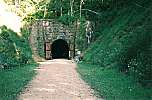 Before entering, I took a couple of pictures of this great tunnel.
It was much more than what I'd expected. Nestled in the thick woods
against a solid stone cliff is a great stone brick facade about
twenty five feet high with two high wooden doors, opened to the dark
mouth of the tunnel. The doors were necessary in the railroad days to
keep the inside of the tunnel from freezing in the winter. Workers
were kept at each end of the tunnel and would open the doors when a
train needed to pass.
Before entering, I took a couple of pictures of this great tunnel.
It was much more than what I'd expected. Nestled in the thick woods
against a solid stone cliff is a great stone brick facade about
twenty five feet high with two high wooden doors, opened to the dark
mouth of the tunnel. The doors were necessary in the railroad days to
keep the inside of the tunnel from freezing in the winter. Workers
were kept at each end of the tunnel and would open the doors when a
train needed to pass.
Far away, at the other end of the tunnel, was a small circle of light, the size of a dime. I got my bike light out and began walking through the tunnel. It's three fourths of a mile long and you can hear every sound, including the whispers of other people, throughout the tunnel. Pointing my light up and looking around I could see the rock ceiling. The whole effect was very eerie. I could see the small pale lights of flashlights as people were walking towards me. It was very hard to judge distance.
I saw the light at the end of the tunnel when I entered. After walking, for what seemed a long time, I noticed that the light at the end was getting bigger. It looked about the size of a silver dollar held at arm's length. I thought I was getting close. To my surprise, when I looked back, the opening I'd entered through still loomed large, the size of a football.
Since no one else was near, I mounted my bike and began riding very slowly. There is a lot of water inside the tunnel, constantly dropping to the floor and echoing in an aquatic symphony of drops and plops. The whole time you can hear the murmur of adults and children, off in the dark, talking so as not to be heard.
Eventually, the light at the end of the tunnel became larger than the opening I had entered and, once again walking, I emerged from the darkness. Hey! This is fun.
There was a small shack near the south end of tunnel #3 that was used by the doormen. Next to it was a pump and, after throwing the handle up and down a few times, what exuded from it was the clearest water you could hope for. I quickly emptied the iron rich water from my bottles, rinsed them thoroughly, and filled up. This water was very refreshing. There were some placards in the building to read, but as sunset was approaching, I remounted my trusty steed and pushed on.
The trail sped downhill through the town of Norwalk, and then back uphill towards tunnel #2 -- six miles from tunnel #3. There were fewer people on the trail, but I still shared tunnel #2 with several other parties. Some younger folks started whistling and humming loud drone notes. The effect would be beautiful if done right. I droned along, in harmony, and occasionally whistled quietly. No one could ever tell who was making these ghost-like sounds. They probably frighten small children, of which there were a few, so I kept it to a minimum.
Tunnel #2, and tunnel #1, are a quarter of a mile long. Much shorter
than tunnel #3, but still long enough to be eerie. I emerged from
tunnel #2 and rode through the town of Wilton. Along the trail there
was a map describing the rest of the route and the elevation gains.
There was one more climb, five miles up to tunnel #1, and then a nine
mile descent to the town of Kendall followed by a flat six mile ride
to Elroy.
Just past Wilton, I came across a private campground adjacent to the
trail. There were plenty of people there, and the campfire smoke hung
thick in the air. I was tempted to stay as it looked like a fine
place, with a small general store and showers, but I was expecting to
find a campground in Elroy and I wanted to cover another fifteen or
more miles that day. I would highly recommend that anyone else
riding this trail make plans to stay at this campground -- The Tunnel
Trail Campground in Wilton, Wisconsin. Their ad says "naturally
mosquito free."
After a five mile climb, I approached the entrance to tunnel #1. The
sun had set and the air was chilled in the twilight. There were no
other people on the trail. I had it to myself. Knowing that the
rest of the ride was essentially downhill for the next fifteen miles,
I decided to kick back -- Miller time. I'd been carrying a couple of
beers with me all day. Having been nestled deep inside my packs, on a
mild day, they were still fairly cool. I stood at the entrance to
tunnel #1 and drank a beer. Just before I finished, a lone biker
passed me and entered the tunnel.
When I emerged from the tunnel the air was much cooler and the colors
were beginning to fade into the twilight. I put on a sweatshirt and
gloves to ward off the chilly evening air. I pedaled over twenty
miles an hour, descending from tunnel #1, at 1200 feet elevation, and
through the town of Kendall. Elroy is at 800 feet. It was getting
dark and the only campground I saw was primitive (no amenities) and
empty. I pedaled into the town of Elroy just as it became dark
enough to require a light.
Not knowing what to do, I stopped at one of the taverns in this
little town. The first thing I did was sit at the bar and enjoy a 35
cent beer. I hadn't seen this kind of bar in many a year. The
glasses are small, but for pocket change you can have a couple of
beers. I asked about campgrounds, lodging, and food. The locals
told me that it was okay to camp in the city park and that there were
showers available at the civic recreation center, but it was surely
much too cold. There was also a motel about a mile or two south of
town. A woman at the bar jumped up, went to the phone, and reserved
a room for me. I liked the idea, too. It was getting pretty cold
and there would be no company in the park in Elroy.
Food seemed like a problem. There was none being served here and
they didn't think anyone else would be serving tonight. They told me
to check the other taverns down the street. Heading south towards
the motel, I stopped at the Sunshine Bar looking for food. There was
an old cowboy, dressed in black playing some slick guitar licks
through his small amp, wearing a radio controlled microphone on his
head, like Madonna, with no guitar cord either. He was walking
around the back of the bar playing some fine versions of Hank
Williams and Johnny Cash songs, just to name a few. I sat at the bar
and had a beer. I asked the bartender, a handsome, country woman,
about 30, if I could still get something to eat. She said, "Anytime
hon. You want to go get your motel room and come back? I'll fix
something then. Don't worry hon."
I finished my beer and rode, in the dark, to the outskirts of town
and the Valley Inn motor hotel. A nice elderly couple were watching
TV and the wife came over to the desk. I requested a room around
back, as I'd seen some folks gathered around a fire in a barbecue
grill with bicycles and a couple of RV's parked nearby. I got a
fine, clean, big room around the back and I unloaded.
I walked out to the folks at the firepit and found a bunch of older
people sitting around with beers, chatting, and having a fine time.
I brought my own beer and asked for a seat. When they heard about my
bike trip they kept me busy answering questions for nearly half an
hour. They'd ridden the Sparta-Elroy Trail that day and were going
to drive home the next day -- Sunday.
I showered and rode back to the Sunshine Bar where Laura, the lovable
bartender, cooked up a fine steak sandwich with fries. The beers
were making me feel right comfortable, and the Johnny Cash fella was
still twanging out tasty licks on his electric guitar, so I planted
myself on a bar stool and stayed for the duration. I got to meet and
talk to a number of the locals. The biggest joke amongst them is
accusing each other of being inbred Amish. Laura was the brunt of
most of these jovial insults.
I met some gals that had driven miles to get there that night. They
worked in a dime store together and were in Elroy looking for a good
time. I could have been part of it, but they left for another bar
and I stayed planted on my stool.
Some local youngsters, probably under age, came in and started giving
Laura a hard time. She didn't need any help holding up her own.
When it was late, near closing, Laura came over and whispered to me
-- "would I like to smoke a thin one with her after she closed?" I
couldn't refuse. She was going to take a while closing the bar, so I
told her to meet me at my motel room. I rode back to my room and
waited.
She got there quickly, spun one, and we smoked. She told me about
her two kids and the farm she and her husband own. She runs the
farm, takes care of the kids, and works at the bar. She thought me
quite the vagabond and enjoyed my company in the motel room. She
braided my hair. She said I'd see her silos reaching into the air
when I left town. I'd been alone on the road a long time. I wanted
to be with her, but it wasn't right. I wasn't sure of her intentions
and I didn't want to insult either of us so, I hugged her before she
left. She had to get up in the morning to get the kids off to
school.
"I sat on the rug, biding my time, smoking her kind.
We talked until three and then she left.
It's time for bed."
Even after the night before -- the beer, the smoke and late night
company, I got up at 10:00, and was on the road by 11:00. No
breakfast, no shower.
The day before I'd traveled nearly 90 miles averaging 12.8 miles per
hour. I'd climbed a total of 1370 feet, although it hadn't seemed
like much since it was all at a 3% grade. I was still covering about
10 miles an hour over the course of a day. In 16 days, I'd ridden
1168 miles.
I wasn't sure of my exact route for this day. I knew that I'd start
by taking
The "400" Trail,
which runs south from Elroy to Reedsburg.
The "400" Trail covers another 22 miles, so over the course of these
two days I spent 100 miles on trail. From Reedsburg on, I was
undecided. I figured that I could make Madison, but I wasn't sure of
my route or if I could ride that far. Madison was 80 miles away and
I'd be arriving a little late. I noticed there was a ferry crossing
south of Baraboo and I made that one of my main objectives. Crossing
a lake on a boat sounded like an adventure.
Conveniently, the "400" Trail passed directly across the street from
the Valley Inn motor hotel. I packed up and crossed over the road
and grass to intersect the "400" trail. The night before, Laura had
mentioned a popular breakfast spot in Union Center that would be
crowded on a Sunday morning because the food was so good. I put my
head down in preparation for grunting out the few miles to Union
Center and breakfast.
Once again, I didn't have the detailed map available from the
trailhead, so I didn't know that Union Center was exactly four miles
south of Elroy. My other maps were not that specific. I saw a sign
at a road crossing for a restaurant at a country club, but decided
against that choice. I lifted my water bottle and swung my head
back, taking great swigs of water to ward off the hunger pangs and
cotton mouth. When I looked back down onto the trail I saw a little
green pickup coming my way. Oh shit! Not on Sunday, too.
This ranger was as courteous as the one I'd met the day before. I
bought a $2, daily permit and, standing on the trail in the middle of
a large marsh, we talked about the cool, humid, unsettled weather.
The cloudy sky was wavering between clearing and darkening. The
ranger predicted rain for me. Especially as I headed south. I asked
about the breakfast spot in Union Center and he said that I'd already
passed Union Center. (I was grunting along, starved, and in an early
morning "fog" that I'd made for myself.)
"Didn't you see the sign for the Country Club Inn? That was Union
Center. Wonewoc is just another couple of miles down the trail,
though, and if you go one block off the trail you'll find a fine
cafe. I eat there often."
Maybe the two bucks are worth it for the information, and advice.
The main street of Wonewoc runs parallel to the trail, one block
east. I turned off the trail and into town. I stopped at the first
cafe that was open. It was in a long room with a counter running the
length of one side with a few tables across the floor, on the other
side. The picture window size opening to the kitchen was at the back
of the room. An older woman with black hair and a little waitress
cap came behind the counter and took my order. Orange juice, two
pancakes, one egg, over easy, coffee and a glass of milk. The egg
was for long term energy and the coffee, unusual for me, was to burn
off the fog.
While I was eating, the cook told Norma, her mother, the waitress,
that she should knock off and go to church. After what was no little
amount of coaxing, Norma decided it was okay and took off her
waitress cap, put on a wool overcoat and joined some friends that had
stopped by to ask her to church. Norma's daughter could handle the
place on a Sunday morning. I was the only customer. After paying my
tab and leaving a tip for Norma, I asked her daughter to fill my
liter and a half water bottle in the kitchen.
As I studied my map, I began picking a route east from Reedsburg,
then south through Baraboo to the town of Merrimac where I could take
the ferry across Lake Wisconsin. I was warming up, so I removed my
sweatshirt. Before leaving town, I stopped and bought a couple of
bananas at a small grocery store.
Between Wonewoc and LaValle, 7.5 miles, horses are allowed on the
trail. I decided to try riding on the highway that parallels the
trail, for this and other reasons. I wanted to make good time so
that I would arrive in Madison before dark. There is just enough
extra friction on the limestone trails that the highway has a faster
surface. There didn't seem to be much wind, so, just south of
Wonewoc, I left the shelter of the trail and began riding on the
smooth pavement of highway 33.
I was wrong on two counts: the wind, and the hills. There was a
fairly good headwind coming out of the south and the road climbed
steeply over hills. The trail, on the other hand, which I could see
angling away from me, into the distance, followed the Baraboo river,
so it covered flatter terrain and, being railroad grade, never
climbed at a rate greater than 3%. I grunted out seven more miles,
over steep hills, sharing the road with fast moving cars and trucks,
my trail permit flapping in the strong headwind. Nice try, Chucko.
About half way between LaValle and Reedsburg, placed in the middle of
a small clearing along the trail, was a large rock with a plaque on
it. I stopped, read the plaque, and took a picture of it for later
reference. The picture is somewhat out of focus, but I can still
decipher all but Mike's last name.
Mike's Place
This land between the Old 400 Trail and the Baraboo River is
dedicated to Mike Beuthling[?]. He eagerly biked the trails and
canoed the streams through the woodlands he loved. Rest a moment,
regain your strength, and refresh your spirit before continuing your
journey.
. . . Amen . . . . . I took some slow, deep breaths and relaxed a
while.
I passed some older folks riding towards me from Reedsburg and before
long I was at the end of the trail. There was a sign describing the
detour around Reedsburg's torn up main street. There was also a
mailbox full of brochures describing the amenities available in
Reedsburg and maps of the Old 400 Trail. I took a map to reference
while writing this article and noted that Union Center is exactly
four miles south of Elroy. I drew a facsimile of the detour route
onto my map. Reedsburg is a relatively big town with a population of
5,000. The other towns I'd passed today had well under 1,000 people.
As I entered downtown Reedsburg I was struck by a few rain drops. I
stopped at a super market to make ready for the rain with covers for
my panniers and garbage bags for my tent and sleeping bag. While I
was doing that I noticed that my chain was gritty with limestone
dust. I'd heard a little squeaking as I rode into Reedsburg, too. I
took out a small bottle of Pace Line oil and emptied it on my chain.
The raindrops subsided as I rode out of Reedsburg.
On this day and the next I relied heavily on the
Wisconsin State Bicycling maps
to find my route. I kept the appropriate map folded
up in the transparent top of my handlebar bag at all times, nearly
destroying one of them in the rain. I tried following the suggested,
green route, out of Reedsburg, but became impatient with it and
turned back out to highway 33, which was marked red, unsuitable. The
highway was fine with me.
The wind was more from the east now and I was riding right into it.
A mile or two outside of Reedsburg the rain gods regaled and it began
to pour. I pulled over near a dairy farm to put on my nylon rain
jacket, and to put large, heavy-duty, zip-loc bags over my shoes. It
was slow going, into the wind, but it was a beautiful, green day,
with a low ceiling of clouds tinted steel-blue, and I was staying
warm as I pedaled through the rain.
I patiently made my way east to highway 12, one of Wisconsin's main
arteries. The topographic shading and curvature of the roads on the
Wisconsin Bicycling map made it seem as though most of the big hills
were west of here, so I was carefully picking a route that stayed to
the east. The rain fell harder, so I slid the hood of my jacket over
my head. Water was running down my face and off my bare legs. The
tires hissed as they sliced through the thin, transparent layer of
water on the dark pavement.
When I turned south towards Baraboo, the rain slowed to a light
drizzle and the wind, merely a breeze, was no longer in my face. I
entered West Baraboo along a commercial strip of fast food
restaurants, strip malls, gas stations, and large auto dealerships.
When I entered downtown Baraboo I followed signs to highway 113, the
most direct route, although marked red, to Merrimac and the ferry
across Lake Wisconsin.
Near the south end of town, I stopped at a convenience store/gas mart
for a break. I had a fifty cent hot dog and a carton of milk. While
standing under the dripping eave, a man about my age, with a British
accent, asked about my trip. When I told him I'd cycled from Boulder
he said he was with a friend that had driven from there just the day
before. His friend, an oriental looking woman, walked out of the
convenience store and he told her where I'd come from. I wasn't
standing by my bicycle, so she, like many other people I'd met,
assumed that I'd ridden a motorcycle from Boulder. When her friend
made it clear what I'd done, she was shocked. She'd driven straight
through the day before and couldn't imagine cycling that distance.
Coincidentally, they were driving to Madison later in the day, so I
asked about my route along 113 and to the ferry boat (Sidhartha was
surely going to be there). The man agreed that my choice was the
most direct and said that it was not heavily traveled, either. I
said farewell and asked them to give me a honk and a wave if they saw
me later in the day. I didn't see them again.
Leaving town, I dove rapidly into the Baraboo River valley and past
the Circus Museum, an outdoor amusement park and museum. The other
side of the river valley has a steep 500 foot climb that left me
steaming, literally. It was the only hard climb I'd encountered
other than the one in Bay City a couple of days earlier. I
down-shifted and patiently found my way to the top. When I got there
the rain started coming down hard again. I descended a steep hill at
35 miles an hour with water spraying in my face and on my cold legs.
As I rode south, the rain subsided. I missed a turnoff that I wanted
to take at Palfrey's Glen Road. I didn't see a road sign, but I had
noticed a sign advertising a restaurant. That was a green route, but
I missed it. I stayed on a red road. While looking for the turnoff
I ran into the dead end at highway 78 and rode east into the town of
Merrimac, where it had quit raining for the moment.
I turned towards the ferry landing, down a short street full of cars.
I passed the cars and stopped at one of the two concession stands by
the dock. The ferry was just starting to make the quarter to half a
mile journey across the narrow end of Lake Wisconsin. It could hold
about a dozen cars, in three rows, and traveled along cables
stretched across the lake under the water. While I was waiting for
the ferry to make it's round trip I bought a carton of milk and made
a peanut butter and jelly sandwich. My lunch was ready when the
ferry returned. One by one, the three metal ramps were lowered and
the cars drove off. As I walked my bike up the ramp and towards the
front of the boat the captain nodded. I ate my lunch and took a
couple of pictures on this short boat ride.
Once on the other side, the rain began again. I followed highway 113
over large rolling hills, through farmland, and an occasional town --
Okee, Lodi, and Dane. It rained on and off until it quit for good
near Dane. As I was shifting up and down, riding over the long,
sometimes steep rollers, my chain started slipping in the upper
gears. It was making a gnashing sound, too. The combination of rain
and oil had washed the limestone grit into the pins and rollers of
the chain. Then the rain washed off any remaining oil and left it
dry. I made several adjustments to my derailleur as I rode along. I
have thumb shifters with an adjustment nut on the shifter, itself. I
tried turning it a quarter of a turn at a time to take the slack out
of the cable. After a few turns, other gears would start to slip. I
cranked it back and forth several times until I found the happy
little "g" spot where all of my "g"ears worked without slipping. All
this adjusting made the time pass quickly.
At Dane, about 15 miles north of Madison, the road took several 90
degree turns, first east, then south, then east, then south, and so
on. This broke the rest of the ride to Madison up into short, one to
three mile sections. When I turned east the first time, into Dane, a
horrendous headwind blasted me, nearly bringing me to a standstill.
Luckily, the wind dissipated after I turned south and then east
again. The hills became shallower, too.
I entered Madison through Waunakee on Woodland Drive through a new
subdivision with large wooded lots and estate size homes. I felt
fabulous. The rain had stopped and the setting sun was visible
through clouds on the horizon. The wind was gone, my gears were
working, and I was nearly in Madison. Then I took a turn, west on
county M, around Lake Mendota towards Middleton. I keep a compass in
the transparent top of my handlebar bag, and it's occasions like this
where it proves worthwhile. After noticing that I'd been traveling
west for over two miles (I should have been going east and south), I
turned around.
By the time I entered north Madison it was getting dark and I was on
a major, four lane street. Since my tail light cannot be seen when
my sleeping gear is in garbage bags, I did some riding on the
sidewalk. I ended up on the east side of Madison, in the dark,
looking for motels. Guess where I stopped to ask for help? A liquor
store was all that was open in the strip mall where I stopped. The
owner and his wife were very kind and helpful. They told me to ride
north for a couple of miles (on Washington, I believe?) until I saw
the cheaper motels.
I was looking for the right combination; convenient liquor store,
grocery store, and restaurant. I rode a while, in the dark, without
seeing the right combination. When I saw the Spence Motel, with a
sign advertising rooms for $24.95, I stopped looking. I was wet and
weary and my chain was crying out with a grinding noise from all the
dry grit. I pulled up past an idling semi-trailer, it's diesel
engine clattering away, and got a room. I showered, got a six pack,
a burrito to go at Pedro's Mexican restaurant behind the motel, and
went back to my room. Since there was a laundromat nearby, I used a
drier to dry the clothes that I'd washed in the shower.
When I looked over my maps to plan the next day's route, I saw that I
had serendipitously ended up right where I needed to be; at the
entrance to highway 51. Following that south for a couple of miles
would take me to county road BB, Cottage Grove Rd. Once in Cottage
Grove I could pick up another bike trail that would lead me to the
best green route, south towards Janesville. All I needed to do the
next morning, before leaving, was find a bike shop. I was out of oil
and my chain sounded like it was about to self destruct. Looking in
the phone book I saw that there was a Schwinn shop just a couple of
blocks north of the motel. They opened at 10. An excuse to sleep a
little late. (Like I needed one. It was an excuse, nonetheless).
I was ready to completely relax, turn off my mind and float
downstream. When I flipped on the TV, much to my surprise and
enjoyment, the season premier of Star Trek: TNG came on. It was the
follow up to a cliff hanger at last season's end. What a fine gift
at the end of a fine Sunday.
I'd ridden 80 miles to get to Madison, 84 to my motel. It had been a
full day. Trails, rain, the ferry crossing, wind, hills,
disorientation, the big city of Madison, and now, as the day ended, a
new episode of Star Trek. I'd averaged 12.7 miles an hour from 11:00
until about 8:00, and, to my surprise, climbed 2240 feet. That was
the most I'd done in one day since leaving home. I was 1252 miles
from home.
By the time I awoke and opened my door, it had already rained once.
The pavement was damp and the sky was dark with low, heavy clouds.
Serene, in the cool, unsettled morning, I packed my gear into rain
covers and garbage bags. I rode to the bike shop, rolled my bike in
the door, and removed all my gear. I wanted to buy a replacement
bottle of Pace Line oil and use it, but they were all out.
Instead, the owner took my bike back into the shop, and while rapidly
spinning the freewheel, sprayed it for several seconds with Schwinn
heavy duty lube. Black muck dripped off onto the floor. He then
took a lighter weight oil and applied it to the chain. I thanked him
heartily, as the gnashing chain noise the night before had been
destructive. Everything sounded fine now. I repacked my gear and
rolled out the door.
I headed south on highway 51, a busy four lane thoroughfare, towards
Cottage Grove Road, or county BB, as it is also called. I was only
five minutes out when the rain came down in a cascade. I stood on
the shoulder, traffic spraying me with wet grime, and put on my rain
jacket, hood, and zip-loc boots. I looped up and around a cloverleaf
and began riding east on Cottage Grove Rd.
I was nearly out of money, so seeing a bank, and not knowing what lay
ahead, I stopped to get a cash advance from my good friend, Mr. Visa.
No one in the bank could make sense of what I was doing, standing
there, dripping, and talking about my intention to ride all day into
Illinois. My presence that morning broke up an otherwise normal day
and, at least, provided a distraction. I noticed that a young
mother, babe in arms and child in hand, had dropped her wallet by the
lobby desk. I picked it up for her.
I returned to the rain hungry, as I'd not had any breakfast. I was
determined to make it to Cottage Grove before stopping. I crossed
over interstate 90 and rode through an urban setting until I reached
the more rural Cottage Grove. I turned off towards town to look for
a diner, but not seeing one, returned to the county road and the gas
station and general store on the corner. I found a veritable feast
inside. There were, fresh home made rolls and sandwiches. I bought
some juice, an apple, a banana, a huge banana nut muffin, an egg,
cheese, and sausage sandwich on an english muffin (microwaved to a
warm glow), and a carton of milk. After asking about the location of
the bike trail, I sat outside and consumed this feast. I saved the
apple.
I rode back towards town. Just past a deceptively silent, but full,
school house, was the trail head for the
Glacial Drumlin Trail.
This is another flat, limestone trail that runs straight through farm,
wood, and marshlands. It is 47 miles long and ends just west of
Milwaukee. The rain was steady, sometimes subsiding to no more than a
misty drizzle. Feeling a chill, I put sandwich size zip-loc bags
over my hands to keep them dry and out of the wind.
I only needed to ride six miles on the trail, to county road W, which
took me south towards interstate 94. There were puddles along the
way, but the only real obstacle was frogs, little brown, wart covered
frogs. I had to keep my eyes focused on the trail to avoid hitting
them.
While I was on this section of trail I passed a fellow jogging with a
big golden dog, Niki. I had no trouble passing them, but about a
quarter of a mile down the trail, looking to the side, I saw
something out of the corner of my eye. Niki was keeping pace with
me. I stopped and ordered him to return to his master, who was also
calling him. When I saw that he was definitely on his way back I
waved to let the jogger know that there were no problems. He didn't
wave back. I turned my attention and bicycle back to the trail and
rode on. My hands had warmed up, so I put the baggies back in my
jacket pocket.
I left the trail and headed south on the smooth, paved, county road
W. I climbed several hills, passed old farms, lush green woods, and
a couple of small housing developments. The scenery was soft, wet
greenery. At one point, the rain came down so hard that I sought
refuge under a giant old oak tree in a farmer's driveway.
Up and down, over the short steep hills, I rode. I went under the
interstate and, relying heavily on the Wisconsin State Bicycling map,
began following the green route that parallels interstate 94. One of
my handlebar grips had been loosened by the rain and was twisting
freely on the bar like a motorcycle accelerator. This did nothing to
improve my speed, though.
I passed a golf course while trying to decide where the next turn off
was. There are several small jogs in this route. When I stopped to
read my map, another deluge began. I took cover in an old farm shed
that was used to store private golf carts. I stood inside eating my
apple, watching the rain, glad for the shelter. When I was ready to
leave, the rain had slowed again.
At Albion there was a big truck stop at the interstate exit. I
stopped there, removed my "foot bags," and, looking like a drowned
rat, went inside for a break. I used the facilities, bought a candy
bar and verified my route along Old Goede Rd., which paralleled the
interstate. I could see the interstate traffic and, when I was close
enough, hear the spray that was trailing each vehicle along the road.
A little farther on, I stopped at a McDonalds and ate some hot french
fries. They were delicious. The route was tricky, so I stopped
again and asked for directions at a gas station. "We don't give
directions to people using wet maps," the manager said jokingly. It
was true, my bicycling map was getting soggy sitting in the top of my
handlebar bag. It was falling apart.
My original intention was to go south through Janesville and Beloit,
then down to Rockford or perhaps Belvidere, Illinois, but it looked
like the only route was through downtown Janesville on "unsuitable"
roadway. I changed my mind and headed east through the small town of
Milton, bypassing Janesville and Beloit. I stopped at a convenience
store to ask for help and the store owner made a photocopy of a
detailed, county map for me. I selected a road that is not
categorized on the Wisconsin bicycling map. It's just a thin black
line. For over ten miles I rode on the Milton-Shoppiers road with
little to no traffic, short, steep hills, and a blustery sky. The
rain was beginning to subside.
I rode south and then east to the quaint, little rural town of
Avalon. I met up with Highway 140, which runs straight south to the
Illinois border. It's narrow, with a fair amount of traffic, but I
managed all right.
By the time I got to Clinton, the last town before the Illinois
border, I was hungry, so I stopped at a gas station/mini-mart and had
some orange juice and a microwave cheeseburger. An odd combination,
I know, but it was the best I could do. It caused me some heartburn
problems down the road. While I was there I saw newspaper articles
about Herbe Velachez committing suicide over a lost love. I couldn't
imagine how anyone could become so lost. If all else fails, pack up
some gear and hop on a bicycle. All problems, whether worldly or day
to day, come into an easy perspective. Each day unto itself,
whatever it may bring.
The shop owner told me that Belvidere was another twenty to
twenty-five miles away. I felt at ease. It was about 3:30 and I
knew that I could make it to Belvidere in daylight. As I rode out of
Clinton, the sun made a brief appearance from behind the dispersing
rain clouds. At the Illinois border the hills stopped, the road
condition became markedly worse, and a new species of road-kill
showed up, smeared across the highway, a grey carcass, long, rat-like
tail, and a ghoulish, toothy grin -- possums. I hadn't seen any
until the Illinois border and now I was seeing one every few miles.
The pavement was so chewed up that it looked like they had been
gnawing on it.
I rode south into Belvidere without any more rain. I was definitely
in Illinois; flat road in need of repair and corn fields. I stopped
at State Street on the west end of town. I tried calling a few
motels and decided on the Cambridge Inn. It was a little more
expensive than some other motels I'd stayed in, but it was close,
they'd answered their phone, and it was my last night on the road, so
I saved myself the hassle of looking around and took a room there.
They didn't have a room on the ground floor. I had to carry my gear,
and my bicycle, up a flight of stairs. It was also the first motel
that wouldn't let me put my bike in the room. I didn't argue. It
worked out okay. The room had an outside door and I locked my bike
to the railing along the second floor walkway. It was a quiet,
businessman's motel, so I had no worries. And the bicycle policy
actually made sense. The rooms were like suites, with fine carpeting
and a small living room. Very nice and clean.
I went to the lounge for a beer and met a delightful young polish
woman with blond hair, a lovely smile, and an accent that eluded me
until I asked her where she was from. She had only been in America
about a year and was working at this motel, which her relatives own.
I had an Italian meal delivered to the bar from another restaurant
and sat there watching Monday night football with the few businessmen
seated at the bar. Coincidentally, the Denver Broncos were playing.
But most of all, I could tell, I was back in my home state, Illinois.
The people, places, and things were very familiar. I could feel
Illinois.
The game and the company became boring, so I left the lounge after
the first quarter. Back in my room, I took my soaked shoes (baggies
only work so well) and wet clothes to the drier, showered, and
relaxed in my room. I hadn't noticed until now, but after riding in
the rain all day, my nipples had become painfully tender and red. I
applied some aloe and jojoba lotion that is very good for curing
chafing overnight. The lotion caused a stinging pain that was nearly
unbearable. After it subsided, I was able to rest and watch my old
pal, Dave.
I'd covered 80 miles between 10:30 and 6:30, averaging 13 miles per
hour. I'd climbed nearly 1600 feet, the second most since leaving
home, and considerably more than any one day in Nebraska. I was 1333
miles from home -- my newer home, that is -- tomorrow would be an old
homecoming. The weather forecast called for clear skies and winds
out of the northwest -- blue skies and a tailwind. "Illinois, I'm
your boy."
This was my last day on the road, the day I'd make it to my old
hometown. Spirits from the past were waiting for me at every turn,
and as I got closer to home, they arose over every hill and along
every familiar piece of ground. I hadn't seen some of that ground
for almost twenty five years. It was like riding around a corner,
through time, and into the past. I was delighted to see things that
had not changed. Some old places, however, were unrecognizable.
I started my day in Belvidere a little earlier than usual. The
weather channel on the TV confirmed that the winds would be in my
favor and that there was only a slight chance of rain. There was
morning fog and the sky was overcast, but it looked stable enough.
The clouds were a uniform, light grey, and rain did not seem to be in
the program. I did not feel threatened.
I looked in the phone book for a bicycle shop where, still being
without chain oil, I might find the brand and size bottle that I
prefer. Looking for the map I found the ragged edge of a page where
someone had ripped it out. This was one of my pet peeves throughout
the trip. The fact that people, in their selfish arrogance, will rip
out one of the most important pages in a phone book because they
haven't the time or patience to memorize directions or write them
down. So many pay for the arrogance of so few.
I carried my bicycle and packs down from the second floor, loaded up,
and was on my way by nine ay-em. My chain sounded fine, so I didn't
bother going to the bike shop. The Schwinn heavy duty lube that I
put on the day before had withstood an entire day of heavy rain. I
stopped at a downtown diner in Belvidere for breakfast. The pancakes
tasted funky. Later that day I felt nauseous.
I left the restaurant and headed south, through town, to highway 20,
which runs east and west. I'd picked my route already. Wanting to
stay off the heavily traveled routes and also to see some pretty
little farm towns, I decided to ride to highway 20 and then take
Genoa road south-southeast to the town of Genoa. From there I'd
follow highway 23 to Sycamore. I knew there was a bicycle path
somewhere near Sycamore that would take me all the way to St. Charles
and the Fox River. From there I could pick out the rest of my route.
For the second time on this trip I got confused and took a wrong
turn. Within half a mile, though, looking at the compass in my
handlebar bag, I realized that I was going west, towards Rockford --
the wrong way. I turned around and at the next intersection went to
a gas station to get directions and verify my location.
"I'm looking for the road that goes to Genoa." I said, with emphasis
on the first syllable (GEN-oh-wah).
"You mean gen-OH-wah? That turnoff is just visible over there to
your left, take the county road." said the red jacketed cashier.
Good old Illinoise. Where the locals are too lazy, or are just not
interested enough to pronounce foreign and native American words
properly. In fact, they adamantly insist on the wrong
pronunciations. Her correction made me smile and her directions got
me back on track.
Genoa road crossed over interstate 90, the highway I had been
meandering along the day before in Wisconsin. It's called the
Northwest Tollway in Illinois. I began pedaling, with the wind,
through the flat, familiar, Illinois farm country. The tailwind
allowed me to maintain a speed near twenty miles an hour as I rode
past white farm homes, red barns, and faded, old, rust-colored,
buildings. Harvest season was over and the farms appeared deserted.
I quickly became aware that my nipples were still tender and sore
from riding all day yesterday in the rain. They stood up, rock hard,
and every time my shirt moved across them, be it from air movement or
my body movements, they became even more sore and tender. I knew
what the cure was, but I wasn't carrying any petroleum jelly with me.
I stopped and wadded up two balls of kleenex tissue that I taped over
each nipple with a band-aid. It was just a "band-aid" solution, but
it helped some and allowed me to ride without the burning, rubbing
pain. More important, it prevented me from causing any more damage.
It was a temporary solution, though, and I had to stop from time to
time to adjust the bandages. Having band aids strapped over my
nipples struck me as silly.
The sky remained overcast, yet with no threat of rain. Occasionally
the sun would peek through and I'd swing my sunglasses up over my
eyes, only to drop them again when it disappeared. I like seeing my
surroundings in their natural colors and so avoid wearing sunglasses
unless it is extremely bright or I am traveling fast enough to need
them as a wind guard. My handlebar grips, which had loosened in the
rain the day before, were drying out and beginning to hold steady.
I made great time, rolling into green, green Genoa, an old brick and
stone farm town on the wide open plains west of Chicago. I rode
through town, to highway 23, and then headed south for Sycamore. I'd
ridden to Sycamore a dozen years ago when a friend (whose home was my
destination on this trip) and I rode from St. Charles on a limestone
trail. I was hoping to find this trail when I got to Sycamore.
Riding through the tree-lined streets of Sycamore I came upon the
police station, so I stopped and asked about the bicycle trail. I
believe it's called the Great Western Trail. I was told that I could
pick it up on the east side of town along highway 64.
While in Sycamore, I stopped at a grocery store and bought some
bananas and a jar of petroleum jelly (something generic - Vaseline
was twice the price) . . . Ahhhhhh, greasy comfort on my tender body
parts. A dollop of gel on each nipple protected them from any
further contact with my clothing. I'm adding it to my permanent
packing list.
On the east side of Sycamore, I did, indeed, come across the bicycle
path. It was like the others I'd been on in Minnesota and Wisconsin -
crushed and compacted limestone, shallow grades, and a translucent
archway of trees overhead. I'd been making great time all morning,
so I slowed down to soak up what the day had to offer. St.Charles
and the Fox River were under 20 miles away so I could easily make it
there by 2:00. I pedaled leisurely along the railroad bed past
fields of harvested corn and dried earth.
[This is great cycling country. The roads are flat and there are
small, paved, county roads with little to no traffic. The sky goes
on forever, as do the fields of corn. When I lived in Illinois I
rode my first century from Wheaton to DeKalb and back. The route
west from St. Charles was all on little used farm roads passing
through delightfully quaint farm communities. There's no excuse for
you Illionisans living in the Chicago area. You are near some
optimum bicycle riding terrain. Whether you use the Great Western
Trail or not, the plains west of Chicago provide many routes for long
day trips from 50 to 100 miles - all on nearly deserted farm roads.]
As I neared St. Charles, I wished I had three days to cover the next
fifteen miles. There was so much to see. So many places I'd visited
throughout my adolescent years. I had friends that lived in St.
Charles, and I'd taken many scenic drives past the parks and woods
along the Fox River, on highways 31 and 25. There are too many
memories to enumerate.
I decided how I wanted to enter my old hometown -- Wheaton. I wanted
to come in from the north as this would set me up for a grand tour of
familiar and nostalgic places. When I got to St. Charles, I followed
the bike route signs and crossed the Fox River. Sixteen years ago I
participated in a 26 mile canoe race on the Fox River and had ported
the canoe around a dam and over the bridge I was now crossing.
I headed east on highway 64. This was very dangerous and unnerving,
as it is a four lane highway -- a major, beat up, old truck route
into Chicago, with no shoulder, and heavy traffic.
I passed Fabian Parkway, which would have been the ideal way to head
south and then back east on less traveled routes, but I was intent on
visiting my old hometown from the north and seeing as much as I
could. I followed route 64, or North avenue as it's called, into
DuPage County, past Pheasant Run Inn and Country Club and the DuPage
County Airport. Just before a scarred and decrepit, old,
shoulderless railroad overpass, I spotted what used to be called the
Atomic Bar. It used to have a neon sign depicting the nucleus of an
atom with its orbiting electrons - a ball with two crossed ellipses.
It had a new name now, but it was still the same kind of place. I
had been afraid to go there when I lived in the area -- too red neck
and scary a place. Today, it didn't bother me at all. I knew that
the Prairie Path, another "rails to trails" path, crossed North
Avenue somewhere near here, so I stopped to ask if anyone knew where.
I leaned my bike against the wood siding outside and entered the dank
little bar. It wasn't quite 3:00, yet the bar was full of blue
collar workers that had knocked off for the day. Bleary eyes watched
me as I approached the bar. I wasn't ready for a beer quite yet, it
was too early in the day, but rather than ask for directions I
followed afternoon tavern protocol. I made a flirtatious, sexist
comment to the bartender and ordered a beer. And then another. Once
I knew I might be accepted into this tight-knit little society, I
started asking for directions to the Prairie Path. I had to explain
a number of times that I was on a pedal bicycle, and not a
motorcycle. When they finally understood they were actually
impressed and a young, drywall-hanging, Bears fan took it upon
himself to summarize all of the advice coming my way and explain my
route -- right down to how I could time my climb over the railroad
overpass with the red light outside. Once the light turned red and
stopped the traffic, I could make it over the viaduct without being
sucked under the wheels of some six-wheel gravel truck -- if I
hurried.
I left the old Atomic Bar and, after waiting for the light at the
intersection to turn red, sprinted up and over the old overpass.
When I got to route 59, I turned south to an old wooded housing
development and was able to wind through safer streets towards north
Wheaton. The Indian Knolls subdivision is a beautifully wooded
development with large old homes on multi-acred lots full of giant
deciduous trees -- oaks and elms.
The rest of my ride was a personal journey that I can't describe with
a depth and detail consistent with how it felt, but I'll summarize
quickly. First, I rode past my old girlfriend's house -- my high
school steady. She was perfect figured, blonde haired, fair skinned,
and the first love of my life -- the one I can't forget -- the one by
which all others, when held up in comparison, come up short. I'd
spent a lot of joyous days and nights at her house and learned a lot
of things there. I separated after I went to college in 1969 -- to
be changed forever -- while she stayed at home to finish high school.
During our last summer together we double-dated a lot with a friend
of hers, Sandy, and her boyfriend, Randy. Drive-ins were still
popular at the time. Later, in the fall, when I was at school, my
girl called me from home to say that Randy had stepped on a landmine
in Viet Nam and was gone from us. I flung a shoe that crashed
through the window of my college dorm room and clenched my teeth
tightly. A clench it took years to lose.
I hadn't seen this neighborhood in twenty five years. In that time
it had gone from bare little plots with ranch homes and young
saplings tied to stakes (which we had watered with bucketfulls), to a
mature, old neighborhood with huge shade trees. Tears of nostalgic
joy welled up in my eyes. I left all those silent, life shaping
memories to ride on the Prairie Path through north Wheaton.
Again, the memories, too many to fathom individually, flooded in and
I became as bleary eyed as the Atomic Bar patrons. The Prairie Path
was intact and was protecting some valuable wetland just on the
outskirts of town. I was impressed by this conservation effort. At
the far end of a marsh, I saw a heron fishing in a pond near some
high reeds. Just a couple hundred feet beyond that was a building
supply yard and a woman's voice blaring over a loudspeaker, "Ross,
please come to the service desk. Ross Sanderson, please come to the
service desk." The heron, who'd apparently acclimated to this aural
pollution, kept on fishing with its statuesque posture and long beak
poised over the shallow pond in perfected patience.
I once had a girl friend, more of an acquaintance really, that lived
near the Prairie Path. I was 19 years old and had just bought the
acoustic guitar that I still play and cherish to this day. We wrote
songs together. One afternoon she had gone hiking and was late
returning home, where I was waiting to take her out. Some friends,
her sister, and I searched for her, but finally, much later, she
returned home on her own. She didn't tell anyone her whole story
until we were at the police station and I was asked to leave the
room. She had been raped at knife point while hiking along this
section of path. That was 1970, and I haven't seen her since that
day.
I rode on, into downtown Wheaton, and stopped at the popcorn shop, a
three foot wide, thirty foot long hallway of a store that had been
there since long before my youth. I'd spent many an afternoon
flirting with a high school friend that worked there. The new owner
was there and I shared my memories with him as I picked through the
penny candy selection along the wall.
After leaving there I stopped at the all night restaurant I'd
frequented after graduating from high school, "Round the Clock." I
had a grilled cheese sandwich and a glass of milk. "Mr. Stinks," the
town looney, of whom many far fetched stories had been told, was
sitting on a stool at the counter. As kids we used to mock and taunt
this old man. "Mr. Stinks," we'd shout, as he took his daily stroll
through town. That had been thirty years ago and he was still here.
He'd outlasted us all. This was his town, after all, not ours. He'd
won. I wonder if the children still taunt him. He still had the
same shy, mole-like appearance, unchanged in thirty years.
I called my friend at Bell Labs in Naperville, where I worked when I
was raising my own family and still living in Wheaton. I arranged to
meet her at her house in downtown Naperville around 6:00 PM. I left
town and rode past my old high school. It was built in the
nineteen-twenties, and the football stadium had been named after an
old alma mater, Red Grange. The school was now, sadly, a junior high
school and the field had even been renamed. Things change.
Riding through the neighborhood of my childhood, where I lived while
I still attended junior and senior high school, I saw a white haired
old woman in the front yard of an old friend's house -- just kitty
corner from my old home.
"Mrs. MacCallum?"
She looked up in surprise to see a bearded, pony-tailed vagabond on
his touring bicycle. I explained who I was and she remembered
immediately. She asked me to stay and visit with her and Mr.
MacCallum. Then she insisted on feeding me. I never eat fresh,
sliced tomatoes, but when she brought me a ham sandwich with fresh
tomatoes I quietly ate it.
I had missed my friend, Bruce, by minutes. He's a school teacher and
family man, and had stopped by his folks house before going home.
I'D JUST MISSED HIM! Still, it was an enjoyable, nostalgic visit. I
thanked my gracious hosts, leaving them with a couple of wild, road
stories and rode on, past the townhome I'd owned just before moving
to Boulder. I was surprised by the unbelievable buildup of malls,
banks, and office buildings in the farm fields that had been there
just ten years ago. The area was unrecognizable, but I navigated
down Naperville road, through the Bell Labs parking lot and on to my
friend's house in Naperville.
On the way there, a cycling club, out on an afternoon ride, came up
from behind so fast and unexpectedly, that they nearly blew me off
the road. Someone near the end of the paceline was human enough to
apologize for nearly knocking me down as they sailed past. I was a
little outraged, but another feeling took precedence. I'd ridden in
Bell Labs club rides when I lived here and I thought that this might
be the them, so I sprinted, packs and all, and caught up with this
neon, lycra, and Oakley cladded, racing pace line. In speech, halted
by lack of breath, I asked if they were from Bell Labs. "No," was
all that one of them had to say.
I turned away and rode on to my friend's, proud that I had caught up
with their fricking pace line on my fully loaded MTB. I know they
didn't do anything wrong, and had acted without malice, but it burned
me. It was as though they were shunning me. And then I remembered
some of the reasons why I wanted to leave Chicago for Colorado.
I had dinner at my friend's house in Naperville where her 20 year old
son, taken by my adventurous spirit, gave me a "Rambo-like" survival
knife, complete with compass and a fishing hook, line, and waterproof
matches in the handle. It's a great gift. My camping buddies are
going to be impressed this summer when I show up with the
"coo-oolest" knife. After dinner and a short visit, I had to leave
as my friend has a jealous beau. Her son drove me to the home of the
friend that reintroduced me to cycling almost 13 years ago. The home
of the man that has been my best friend for over 25 years. The home
of Bartuch.
I'd been in touch with him during the whole trip by phone from motel
rooms scattered across the plains. He's still my best cycling buddy,
my only cycling buddy, even though we live 1,000 miles apart, and
have for twelve years now. Arriving at his house was easy and
relaxing. He and his wife made me feel quite at home. We had some
beers and talked about bicycle touring. When my friend and I ride
together, we're always evenly matched. We inspire each other to ride
faster and stronger. If one of us sprints away, the other will catch
up and run ahead. Then we'll reunite and ride together at a good
clip until one of us takes up the sprint again. I missed my old
friend and it was a fitting finale to end this tour in the love and
warmth of his and his wife's home.
While I was there we went on some interesting bike rides that I'll
describe in my next article -- Waterfall Glen, Argonne Labs, and
Channahon to Morris on the old Illinois River Canal trail.
On my "last" day (I still didn't know how I was going to get to
Peoria and my ride back to Boulder -- I ended up riding to Peoria) I
had ridden 71 miles. I'd averaged 13.8 miles per hour. Since
leaving home I'd covered 1405 miles and climbed a total of 17,600
feet. And now, here I was, stuck in Willowbrook, in the middle of
the near west Chicago megalopolis. It sure felt different from
central Nebraska, or Boulder, for that matter. But it also felt like
home.
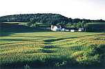 Along the route from Wilton to tunnel #1 the trail passed over
highway 71 on a narrow bridge. Just as I was crossing, the setting
sun illuminated a field of wheat so that it shined golden. A stark,
white farmhouse and attendant silos stood at the far end with a dark
forested hill behind them. As I sat and drank from my clear, sunlit
water bottle, an Amish farmer on his horse drawn cart trotted by
(clip-clop, clip-clop, clip-clop).
Along the route from Wilton to tunnel #1 the trail passed over
highway 71 on a narrow bridge. Just as I was crossing, the setting
sun illuminated a field of wheat so that it shined golden. A stark,
white farmhouse and attendant silos stood at the far end with a dark
forested hill behind them. As I sat and drank from my clear, sunlit
water bottle, an Amish farmer on his horse drawn cart trotted by
(clip-clop, clip-clop, clip-clop).
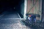 I finished my beer and the noise of the can reverberated as I tossed
it into the tunnel -- just kidding. I opened my other beer and began
walking. I was almost alone. I turned my light off. Dark. I
turned it back on. I took pictures with the flash of my
auto-everything camera. I even rode a bit. When I was about halfway
into the tunnel, the other biker was just reaching the far end. The
carbonation from the beer and a half I'd drunk erupted spontaneously
from my diaphragm -- a real deep barreled, long belch. It caught me
off guard and I laughed out loud. Biker Number One scooted out of the
far end of the tunnel and I never saw him again.
I finished my beer and the noise of the can reverberated as I tossed
it into the tunnel -- just kidding. I opened my other beer and began
walking. I was almost alone. I turned my light off. Dark. I
turned it back on. I took pictures with the flash of my
auto-everything camera. I even rode a bit. When I was about halfway
into the tunnel, the other biker was just reaching the far end. The
carbonation from the beer and a half I'd drunk erupted spontaneously
from my diaphragm -- a real deep barreled, long belch. It caught me
off guard and I laughed out loud. Biker Number One scooted out of the
far end of the tunnel and I never saw him again.
Elroy to Madison - Oil, Water, and Grit
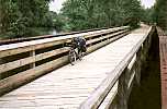 I finally made it to the town of LaValle, and after stopping to ask,
found the rest of the "400" trail. The trail is beautiful here. It
parallels the narrow Baraboo river, which it crosses many times,
through wet woodlands full of flora and fauna. The bridges are made
of old, rusted, steel girders with wooden plank bridges inserted for
trail users. The trees along either side of the trail break up the
wind, which was hardly noticeable now. Ok, maybe the $2 was well
spent. With only eight more miles of trail left, I stopped on the
bridges and in clearings to take pictures and soak up the day.
I finally made it to the town of LaValle, and after stopping to ask,
found the rest of the "400" trail. The trail is beautiful here. It
parallels the narrow Baraboo river, which it crosses many times,
through wet woodlands full of flora and fauna. The bridges are made
of old, rusted, steel girders with wooden plank bridges inserted for
trail users. The trees along either side of the trail break up the
wind, which was hardly noticeable now. Ok, maybe the $2 was well
spent. With only eight more miles of trail left, I stopped on the
bridges and in clearings to take pictures and soak up the day.
                                             Mike's Family and Friends
                                             June 9th, 1992[?]
"It looks like you're gonna have to see me again, --- Illinois," D.
Fogelberg
Homeward Bound